- Screen Colours:
- Normal
- Black & Yellow
NOVEMBER 2023: The Charity has now submitted its response to the LionLink G2 proposal. The document can be viewed HERE
DECEMBER 2022: The Charity's reponse to the original Eurolink proposal can still be viewed HERE
![]()
Walberswick Common Lands Charity is an independent body with its origins dating back to the 1800s. It has been a registered charity since 1901. It is the largest landowner in the Village, responsible for custody of over 162 acres (65 hectares) of land in and around Walberswick.
The land consists of the Common as well as all the other land shaded red on the map below (which is indicative only). This includes the land used for the two beach car parks and the land on which are located the 5 fishing huts, the 33 beach huts and 3 properties by the River Blyth (the ‘Studio’, ‘Craft Room’ and ‘Savoy’). Nearly all of the land is functional permanent endowment land and as such is subject to additional restrictions under charity law.
In addition, the Charity owns the following buildings: the Tea Shed and adjacent Print Room (near the Green), the Bird Hide and multiple-use Storage Shed (both in Bennett’s Drift) and the Community Beach Hut.
The Charity uses the income from its land and properties to manage and conserve the environment and to provide charitable benefit to the Village. The Charity currently has over 100 property agreements. These include access and car parking licences, leases and annual agreements.
The Charity is governed by its Charitable Scheme. This can be found under the Policies & Reports section, along with the the Charity’s Annual Report & Accounts.
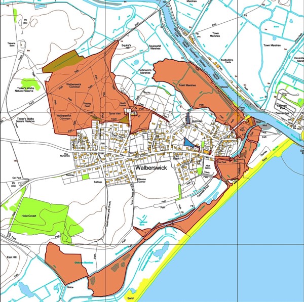
Functional permanent endowment land is indicated in ORANGE on the map.
Other Charity land is in DARK BLUE. These areas are Bennett's Copse, Bennett's Drift and two sections of Sandy Lane
Boundaries are indicative only
For legal boundaries, refer to the relevant title plan